
What is Surveying and Basic Principles of Surveying in Civil Engineering?
Quick answer
Surveying in civil engineering is the process of measuring and mapping the environment to determine the relative positions of points on, above, or beneath the Earth’s surface. It’s essential for planning, designing, and executing construction projects.
The basic principles of surveying include:
- Working from whole to part – control points are established first to minimize errors.
- Location of a point by measurement from two points of reference – ensures accuracy through triangulation or intersection methods.
These principles help achieve precise and reliable results in all types of surveying tasks.
In this article, we’ll delve into the basics of surveying, exploring its role in civil engineering. You’ll learn about the core principles that make surveying indispensable, especially when it comes to building roads, bridges, and other infrastructure. By the end, you’ll have a clear understanding of why surveying is a must-know for anyone interested in civil engineering.
What is Surveying in Civil Engineering?
Surveying is the technique of determining relative positions of different objects on, above, and below the surface of the earth. Surveying is the process of determining the relative positions of points on, above, or beneath the Earth’s surface. In civil engineering, it plays a crucial role in planning, designing, and executing construction projects. Imagine trying to build a bridge without knowing the exact distance across a river. That’s where surveying steps in, providing the precise measurements needed for successful construction. In the surveying method, all the measurements are taken in the horizontal plane. There are different methods of surveying according to various factors. But all of these methods commonly follow two principles of surveying.
Why is Surveying Important?
Surveying is vital because it ensures that structures are built in the right place and with the correct dimensions. Without accurate surveys, buildings could end up on unstable ground, or roads might not meet at the right angles, leading to costly mistakes. Surveyors use various tools and techniques to measure distances, angles, and elevations, ensuring that every aspect of a construction project aligns with the plans.
How Does Surveying Benefit Civil Engineering Projects?
Surveying benefits civil engineering projects in several ways:
- Accuracy in Planning: Surveying provides the data needed for accurate planning. It helps engineers understand the terrain, identify potential obstacles, and design structures that fit the landscape.
- Safety: By ensuring that buildings and roads are constructed in safe locations, surveying helps prevent accidents and structural failures.
- Cost-Effectiveness: Accurate surveys reduce the risk of costly errors, saving time and money in the long run.
- Compliance with Regulations: Surveying ensures that construction projects comply with legal and regulatory requirements, avoiding potential legal issues.
What are the basic principles of surveying in civil engineering?
There are two basic principles of surveying in civil engineering. Those principles of surveying are as follows:
(i) To work from whole to part.
(ii) To locate a new station by taking at least two reference measurements ( linear or angular) from the fixed reference points.
Working from Whole to Part
To work from whole to the part is the main principle of surveying. This principle is followed in order to prevent the accumulation of errors. As the total work is divided into parts, the error of one part will not influence the other parts. As a result, an error will not affect the whole surveying work. This is how the effect of the error is minimized by following the principles of surveying.
This principle is all about accuracy. Surveyors begin by establishing a broad framework of control points across the entire survey area. These points are highly accurate and are used as references. Once the framework is established, surveyors can focus on smaller sections, ensuring that every detail is accurate. This approach prevents errors from accumulating and helps maintain the overall integrity of the survey.
But if the opposite process (i.e., from the part to the whole ) is followed, then the minor errors in the measurement will be magnified. Hence ultimately a situation will come when the effects of those errors will be absolutely out of control.
Explanation :1 (Principles of surveying)
Let us assume that we are measuring a straight line of 30 on fairly level ground. We can measure the distance with a 30 m tape in a single measurement. But due to the long-distance, the self-weight of the tape will affect the measurement. Because of this, there will be a sag in the measurement. Due to this sag, the measured distance will be higher than the original distance.
Now if we divide the distance into a number of spans, the error can be eliminated. Suppose we are measuring the same 30 m distance but in a 3 span of 10 m. Now as the span is small the effect of the self-weight will be eliminated, so the error due to sagging.
Explanation :2 (Principles of surveying)

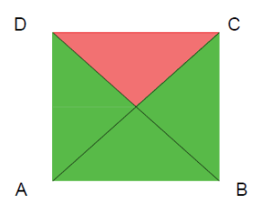
Let’s assume the area of survey work is ABCD as shown in the figure below. During the measurement of the main survey lines (i.e. AB, BC, CD, DA) suppose there was an error in measuring one of the lines, say line CD is incorrect. So now if we calculate the area at a whole, the error in line CD will affect the total area.

But if we divide the total area into a framework of triangles, the error in line CD will no affect the total area. Hence the error will be minimized.
To locate a new station by taking at least two reference measurements
Any new survey stations should always be established by at least two measurements (linear or angular) from fixed reference points. Horizontal distances measured by chain and tape are the linear measurements. Angular measurements are the magnetic bearing or horizontal angle taken by a theodolite or a prismatic compass.
This principle involves determining the position of a point by measuring its distance from two known points. Imagine standing on a soccer field with a friend. If you both measure the distance to a goalpost, you can accurately locate the goalpost’s position. Surveyors use this method to pinpoint exact locations on a site, ensuring that everything is in the right place.
Explanation :(Principles of surveying-2)
Let’s say, two reference points A and B are selected and the length AB is accurately measured. Hence AB line can be plotted to a suitable scale on the paper.
Now the position of any point X can be fixed with reference points A and B by a number of geometrical construction as shown in Fig. 1.1 to Fig. 1.5. The numbers 1 and 2 indicate the two measurements to be taken.
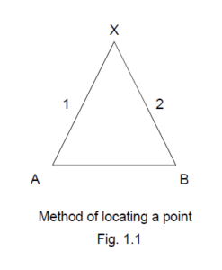
Fig 1.1 – Here the lengths AX and BX are measured and by swinging arc, the position of point X can be established. This method is largely used in chain surveying.
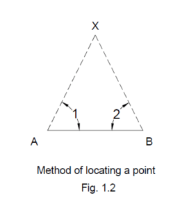
Fig 1.2- Here the angular measurements XAB and XBA are measured and plotting these angles protractor, the position of X can be determined. This method is largely used in triangulation surveying.

Fig 1.3- Here a line XC perpendicular to AC is measured then, the position of X can be determined with the help of a set square.
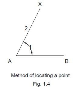
Fig 1.4- Here the angle XAB and distance AX are measured. Then plotting angle XAB by protractor and extending the length up to AX, the position of point X can be determined. This method is generally used in traversing.
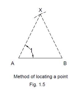
Fig 1.5- Here the angle XAB and distance AX are measured. Then plotting angle XAB by protractor and swinging the arc length of BX, the position of point X can be determined.
These two principles of surveying are very important for controlling and minimizing the accumulation of error. These two principles of surveying also establish a good connection between the field data and the plotting.
What Tools and Equipment are Used in Surveying?
Surveyors use a variety of tools and equipment to carry out their work. Some of the most common include:
1. Theodolite:
A precision instrument used to measure horizontal and vertical angles. Theodolites are essential for tasks like triangulation and leveling.
2. Total Station:
An advanced instrument that combines a theodolite with an electronic distance measurement (EDM) device. Total stations are used for precise measurements of distances, angles, and elevations.
3. Leveling Instrument:
Used to determine elevations and ensure that structures are built level. Examples include automatic levels and laser levels.
4. GPS:
Global Positioning System (GPS) devices provide accurate location data, essential for large-scale surveys and mapping.
5. Measuring Tape:
A simple yet essential tool for measuring short distances. Surveyors use measuring tapes for tasks like marking boundaries and checking distances between points.
What are the Different Types of Surveying?
Surveying is a broad field with several types, each serving a specific purpose in civil engineering. Some of the main types include:
1. Topographic Surveying:
Involves mapping the natural and man-made features of a land area. Topographic surveys are used in the planning and design of roads, bridges, and other infrastructure projects.
2. Boundary Surveying:
Determines the legal boundaries of a property. Boundary surveys are crucial for land ownership and real estate transactions.
3. Construction Surveying:
Provides the precise measurements needed for construction. Construction surveys guide the placement of buildings, roads, and other structures on a site.
4. Hydrographic Surveying:
Focuses on bodies of water. Hydrographic surveys are used to map the bottom of rivers, lakes, and oceans, essential for projects like bridge construction and harbor development.
5. Geodetic Surveying:
Deals with the measurement and mapping of large areas, often on a global scale. Geodetic surveys account for the curvature of the Earth and are used in large infrastructure projects like highways and railways.
How Do Surveyors Ensure Accuracy?
Accuracy is the cornerstone of surveying. Surveyors use several methods to ensure that their measurements are precise:
1. Calibration:
Surveying instruments are regularly calibrated to maintain their accuracy. Calibration ensures that measurements are consistent and reliable.
2. Redundancy:
Surveyors often take multiple measurements of the same point from different angles or positions. This redundancy helps identify and correct errors.
3. Data Validation:
Surveyors validate their data by cross-referencing it with known control points or previous surveys. This validation process ensures that the data is accurate and reliable.
4. Error Analysis:
Surveyors analyze potential sources of error and take steps to minimize them. This might involve using more precise instruments or adjusting the survey method.
5. Quality Control:
Surveying teams often include a quality control officer who reviews the data and methods used. Quality control helps ensure that the final survey meets the required standards of accuracy.
What are the Challenges in Surveying?
Surveying is not without its challenges. Some of the common challenges faced by surveyors include:
1. Weather Conditions:
Bad weather can affect the accuracy of measurements and the functionality of equipment. Surveyors must often work in adverse conditions, making it difficult to obtain precise data.
2. Rough Terrain:
Surveying in mountainous or forested areas can be challenging. Rough terrain can make it difficult to set up equipment and take accurate measurements.
3. Human Error:
Even with advanced equipment, human error can still occur. Surveyors must be diligent and careful to avoid mistakes that could compromise the survey.
4. Equipment Malfunction:
Surveying instruments are complex and can sometimes malfunction. Regular maintenance and calibration are essential to ensure that the equipment is working correctly.
5. Access Issues:
Sometimes, surveyors need to access private property or restricted areas, which can pose legal and logistical challenges.
What are the Do’s and Don’ts in Surveying?
Surveying requires a disciplined approach. Here are some key do’s and don’ts for surveyors:
Do’s:
- Do ensure that all equipment is calibrated and functioning correctly before starting the survey.
- Do double-check measurements and perform independent checks to ensure accuracy.
- Do follow standardized procedures to maintain consistency in measurements.
- Do keep detailed records of all measurements and observations.
- Do respect property boundaries and obtain necessary permissions before entering private land.
Don’ts:
- Don’t rush the survey process. Take your time to ensure accuracy.
- Don’t rely solely on digital equipment; always carry a backup like a measuring tape.
- Don’t ignore environmental factors that could affect measurements, such as temperature or wind.
- Don’t assume that previous surveys are accurate without verification.
- Don’t compromise on safety when working in difficult or hazardous conditions.
FAQs
1. What is the purpose of surveying in civil engineering?
Surveying provides the accurate measurements and data needed for planning, designing, and constructing civil engineering projects. It ensures that structures are built in the correct location and to the proper specifications.
2. How does surveying differ from mapping?
Surveying involves measuring and recording the relative positions of points on the Earth’s surface, while mapping is the process of creating a visual representation of those measurements. Surveying provides the data that maps are based on.
3. What is the most common type of surveying in civil engineering?
Topographic surveying is one of the most common types used in civil engineering. It involves mapping the natural and man-made features of a land area, which is essential for planning and design.
4. How do surveyors ensure their measurements are accurate?
Surveyors ensure accuracy by using calibrated instruments, performing independent checks, validating data against known points, and following standardized procedures.
5. Can GPS replace traditional surveying methods?
While GPS is a valuable tool in surveying, it cannot entirely replace traditional methods. GPS is excellent for large-scale surveys but may lack the precision needed for detailed work in some cases.
6. What are the challenges of surveying in urban areas?
Surveying in urban areas can be challenging due to obstructions like buildings, heavy traffic, and restricted access to certain areas. Surveyors must often find creative solutions to work around these obstacles.
7. How often should surveying equipment be calibrated?
Surveying equipment should be calibrated regularly, ideally before each major project. This ensures that the instruments provide accurate and reliable measurements.
8. What is the principle of working from whole to part?
This principle involves starting with a broad framework of control points and then focusing on smaller sections. It ensures accuracy by preventing errors from accumulating during the survey process.
9. Why is consistency important in surveying?
Consistency ensures that all measurements are reliable and can be compared across different parts of the survey. It is essential for maintaining the accuracy and integrity of the survey data.
10. What are the key skills required for a surveyor?
A surveyor needs strong mathematical skills, attention to detail, problem-solving abilities, and a good understanding of geography and civil engineering principles.
Conclusion
Surveying is a fundamental aspect of civil engineering that ensures projects are built on solid ground, both literally and figuratively. By understanding the basic principles of surveying, civil engineers can ensure that their designs are accurate, safe, and cost-effective. Whether you’re planning a small building or a massive infrastructure project, the role of surveying cannot be overstated. Remember the principles, use the right tools, and always double-check your work to achieve the best results.
Key Takeaways:
- Surveying is essential for accurate planning and execution in civil engineering.
- Understanding and applying the basic principles of surveying ensures accuracy and reliability.
- Tools like theodolites, total stations, and GPS are crucial for precise measurements.
- Challenges like weather, terrain, and human error must be managed carefully.
- Consistency, calibration, and independent checks are vital for ensuring the accuracy of surveys.